Modern name:
Tell al-Lahm
Ancient name (if known):
Kisiga or Kuara
Geographic coordinate:
30° 50′ 0″ – 46° 20′ 0″
30.8333° N – 46.333° E
Governatorate – District – Sub-district:
Dhi-Qar – Suq Ash Shuyukh – al Fadhlyia
Nearest City:
About 18 miles (29 kilometers) southeast of Ur. Ca. 38 km from Nasiriyah; 60 km from Eridu.
Chronological frame:
Early Dynastic-Neo-Babylonian (2700-550 BC)
Excavations:
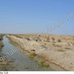
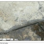
The site of Tell al-Lahm consists of two mounds, with some peripheral ridges, near a dry canal bed. The location was excavated for a few days in 1855 by J.E. Taylor. He found a few inscribed bricks, and a single cuneiform tablet. While he was working at Eridu for the British Museum in 1918, R. Campbell Thompson excavated there briefly. In more recent times, Fuad Safar conducted soundings at Kuara. Looting of the site has been reported, but no damages due to the war, apparently visible in satellite photographs, are to be detected on the ground. Recently, the site has been excavated by Iraqi archaeologists for 4 days.
Historical Remarks:
The possible location of an important city of the Chaldeans in the first millennium BC , Tell al-Lahm (identified as Kisiga-Kisaga or Ku’ara) lays extremely southerly, in the area known as the Sealand, where independent Chaldean dynasties flourished despite the efforts of central Babylonian and Assyrian states to conquer them. There is some association with the goddess Inanna, who had a temple in Kisaga, also mentioned in the Lamentation over the Destruction of Ur as a cult center for Inanna and Dumuzi, conquered by the Elamites when they overran the Ur III state.
In the first millennium, the city appears in texts listing in a row after Ur, Uruk, Larsa, Eridu, Kullab (Uruk sanctuary), areas under control of the Chaldean tribal group Bit (or Dur) Iakin, and in texts and inscriptions of Assyrian and Neo-Babylonian kings. With a location on what would have been the ancient shoreline of the Lower Sea (Persian Gulf), Kisaga was the principal seaport on the mouth of the Euphrates, and dependent on overseas trade, especially with Dilmun (Bahrain). It was also known for its cultivation.
Present Situation:
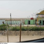
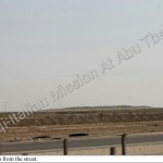
The site is today difficult to be reached. It lays along the highway which connects Baghdad to Basrah (so-called “as-sariyah”) at a distance of ca. 38 km from Nasiriyah and it’s visible from the street (its elevation is noteworthy) – on the other side of the highway there is a mosque where it is possible to use toilets. In order to reach the site it is necessary to u-turn on the highway itself, if coming from Nasiriyah, because no other way is available in the vicinity. There is no paved way to arrive near to the site and the way to reach the Tell is represented by a path created by the frequency of the Bedouins living in the area.
Tell al-Lahm lays of a little modern canal, used for watering and beverage for animals, which is impossible to be crossed by cars, so that it is necessary to walk for at least 1,5 km to come near to the mound.
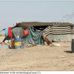
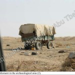
As said, some families of Bedouins have settled in the area, with tents and animals (goats, sheep and camels), and use the place as a waste dump.
Accessibility:
Notwithstanding its visibility from the highway (see Visibility below), the site is quite difficult to reach and it is impossible to come near the Tell with a car; moreover, it obliges the visitor to a long walk of ca. 3 km to and back (see also description above).
Visibility:
The view of the elevation of the tell from the highway is impressive, even if it is impossible to recognize it as an archaeological area if you are not informed or trained as an archaeologist – no shield or information whatsoever is present on the way, in the site or in its vicinity. On the site no structure is visible, mainly because of the lack of scientific diggings. Until the site will be excavated, it is certainly not a place to be shown in a touristic itinerary.
Nome moderno:
Tell al-Lahm
Nome antico:
Kisiga o Kuara
Coordinate Geografiche:
30° 50′ 0″ – 46° 20′ 0″
30.8333° N – 46.333° E
Governatorato-Distretto-Subdistretto:
Dhi-Qar – Suq Ash Shuyukh – al Fadhlyia
Città più vicine:
Circa 18 miglia (29 chilometri) a sud est di Ur. Ca. 38 km da Nassiriya; 60 km da Eridu.
Quadro Cronologico:
Protodinastico- Neobabilonese (2700-550 a.c.)
Scavi:
Il sito di Tell al-Lahm si compone di due tumuli, con alcuni promontori periferici, nei pressi di un letto di un canale asciutto.Il luogo è stato scavato per alcuni giorni nel 1855 da JE Taylor. Egli trovò qualche mattone iscritto, e una sola tavoletta cuneiforme. R. Campbell Thompson mentre lavorava a Eridu per il British Museum nel 1918, ha scavato lì per un breve periodo. In tempi più recenti, Fuad Safar ha condotto sondaggi a Kuara. Il saccheggio del sito è stata segnalato, ma nessun danno è stato causato dalla guerra, apparentemente visibile nelle fotografie satellitari, sono da verificare sul terreno. Recentemente è stato scavato dagli archeologi iracheni per 4 giorni.
Note storiche:
La possibile ubicazione di un’importante città dei Caldei nel primo millennio a.C. , Tell al-Lahm (identificato con Kisiga-Kisaga o Ku’ara) si distende nell’estremo sud, nella zona conosciuta come Sealand, dove dinastie caldei indipendenti fiorirono nonostante gli sforzi dei centri babilonesi e paesi assiri per conquistarli. C’è qualche associazione con la dea Inanna, che aveva un tempio in Kisaga, anch’essa menzionata nel Compianto per la distruzione di Ur come un centro di culto per Inanna e Dumuzi, conquistato dagli Elamiti quando invasero lo Stato di Ur III.
Nel primo millennio, la città appare in testi che elencano nella riga successiva Ur, Uruk, Larsa, Eridu, Kullab (Uruk santuario), le aree sotto il controllo del gruppo tribale della Bit (o Dur) Iakin, e nei testi e iscrizioni di re assiri e neo-babilonese. Posizionata su quello che sarebbe stato l’antica linea di costa del Mare Inferiore (Golfo Persico), Kisaga era il porto principale sulla bocca dell’Eufrate, e dipendente dal commercio estero, in particolare con Dilmun (Bahrain). Era noto anche per la sua coltivazione .
Situazione attuale:
Il sito è oggi difficile da raggiungere. Si estende lungo la strada che collega Baghdad a Bassora (cosiddetto “as-Sariyah”) ad una distanza di ca. 38 km da Nasiriyah ed è visibile dalla strada (la sua altezza è degno di nota) – sull’altro lato c’è una moschea dove è possibile utilizzare servizi igienici. Per raggiungere il sito è necessaria una inversione ad U sulla strada stessa, se provenienti da Nasiriyah, perché nessun altra via è disponibile nelle vicinanze. Non c’è strada lastricata per avvicinarsi al sito e la via per raggiungere il Tell è rappresentato da un percorso creato dalla frequenza dei beduini che vivono nella zona.
Tell al-Lahm dispone di un piccolo canale moderno, utilizzato per l’irrigazione e per la ristorazione degli animali, il quale è impossibile attraversare con le automobili, cosicché è necessario camminare per almeno 1,5 km per avvicinarsi al cumulo.
Come detto, alcune famiglie di beduini si sono stabilite nella zona, con le tende e gli animali (capre, pecore e cammelli), e per utilizzare il luogo come una discarica.
Accessibilità:
Nonostante la sua visibilità dalla strada (vedi visibilità sotto), il sito è abbastanza difficile da raggiungere e non è possibile avvicinarsi al Tell con una macchina; inoltre, il visitatore è costretto a fare una lunga passeggiata di ca. 3 km e ritorno (vedi anche descrizione sopra).
Visibilità:
La vista dell’elevazione del Tell dall’autostrada è impressionante, anche se è impossibile riconoscerlo come una zona archeologica, se non si è informati o addestrati come un archeologo – nessuna protezione o informazioni è presente sulla strada, nel sito o nelle sue vicinanze. Sul sito nessuna struttura è visibile, soprattutto a causa della mancanza di scavi scientifici. Fino a quando esso non sarà scavato, non è certo un posto per essere mostrato in un itinerario turistico.