Modern name:
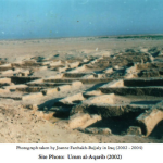
Umm al Aqarib
Geographic coordinate:
31.621105°N 45.933446°E
Governatorate – District – Sub-district:
Dhi-Qar – Al-Rifa’i.
Nearest City:
Seven kilometers south-east of Umma and 30 kilometers west of modern Al Rifa’i. 30 km south-west of modern Qalat Sukar.
Chronological frame:
Ubaid -Early Dynastic, third millennium BC
Excavations:
Looted and excavated in the 90’s by the State Board of Antiquities and Heritage.
Description:
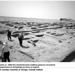
During the late 90’s, the SBAH began to excavate a number of sites which were particularly threatened by looting. One of them was Umm al-Aqarib, which occupies about five square kilometers, with the highest mound of 20 meters above the plain. They uncovered remains of a vast administrative structure, probably a palace and some graves. They also uncovered a tripartite Sumerian temple (Temple H), built of plano-convex bricks, and characteristic of Early Dynastic II-III. Most of the walls were two meters thick,and went down to a depth of seven meters.
Adjacent to the southern wall were solid masses of sun-dried mud bricks, leading to the tip of the mound, which is the highest point in the site. It has been suggested that this might represent a high platform or even a ziggurat, and is a unique example in southern Mesopotamia, instead is always located in the north. Also intriguing was the fact that the courtyard and rooms of the temple had been filled in with clean sand or soil, with no traces of potsherds. Still mysteries are the name of the god worshipped in this temple and the city name.
Nome moderno:
Umm al Aqarib
Coordinate geografiche:
31.621105°N 45.933446°E
Governatorato-Distretto-Subdistretto:
Dhi-Qar – Al-Rifa’i.
Città più vicina:
Sette chilometri a sud-est di Umma e 30 chilometri a ovest della moderna Al Rifa’i. 30 km a sud-ovest della moderna Qalat Sukar.
Quadro cronologico:
Ubaid-Protodinastico, Terzo millennio A.C.
Scavi:
Saccheggiato e scavato negli anni ’90 da parte del Consiglio di Stato dell’antichità e patrimonio.
Descrizione:
Durante la fine degli anni ’90, l’SBAH ha cominciato a scavare una serie di siti che sono stati particolarmente minacciati da saccheggi. Uno di loro era Umm al-Aqarib, che occupa circa cinque chilometri quadrati, con il più alto tumulo di 20 metri sopra il piano. Essi scoprirono resti di una vasta struttura amministrativa, probabilmente un palazzo e alcune tombe. Inoltre trovarono un tempio tripartito sumerico (Tempio H), costruito in mattoni piano-convessi, e caratteristico del Protodinastico II-III. La maggior parte delle pareti erano spesse due metri, e scendevano con una profondità di sette metri. Adiacente alla parete sud erano masse solide di mattoni crudi essiccati al sole, che portano alla cima del tumulo, che è il punto più alto nel sito. E’ stato suggerito che questo potrebbe rappresentare una piattaforma elevata o anche una ziggurat, ed è un esempio unico in Mesopotamia meridionale presente invece sempre al nord. Anche intrigante era il fatto che il cortile e le camere del tempio erano state riempite con sabbia pulita o terra, senza tracce di cocci. Ancora misteriosi sono il nome del dio adorato in questo tempio e il nome della città.