Geographic coordinate:
31° 19′ 29.7120″ - 45° 38′ 18.2400″
31.32492° N – 45.6384° E
Governatorate – District – Sub-district:
Al Muthana – Samawa
Nearest City:
About 50 miles northwest of Ur on an ancient course of the Euphrates. 35 km north-east from Samawa.
Chronological frame:
From late 5th millennium BC to 7th century AD (end of Sassanian period).
Excavations:
The location of Uruk was first scouted by William Loftus in 1849. He excavated there in 1850 and 1854. By Loftus’ own account, he admits that the first excavations were superficial at best, as his financiers forced him to deliver large museum artifacts at a minimal cost. Warka was also scouted by archaeologist Walter Andrae in 1902.
From 1912–1913, Julius Jordan and his team from the German Oriental Society discovered the temple of Ishtar, one of four known temples located at the site. The temples at Uruk were quite remarkable as they were constructed with brick and adorned with colorful mosaics. Jordan also discovered part of the city wall. It was later discovered that this 40 to 50-foot (15 m) high brick wall, probably utilized as a defense mechanism, totally encompassed the city at a length of 9 km (5.6 mi). Utilizing sedimentary strata dating techniques, this wall is estimated to have been erected around 3000 BC. The GOS returned to Uruk in 1928 and excavated until 1939, when World War II intervened. The team was led by Jordan until 1931, then by A. Nöldeke, Ernst Heinrich, and H. J. Lenzen.
The German excavations resumed after the war and were under the direction of Heinrich Lenzen from 1953 to 1967. He was followed in 1968 by J. Schmidt, and in 1978 by R.M. Boehmer. In total, the German archaeologists spent 39 seasons working at Uruk.
Most recently, from 2001 to 2002, German Archaeological Institute team led by Margarite Van Ess, with Joerg Fassbinder and Helmut Becker, conducted a partial magnetometer survey in Uruk. In addition to the geophysical survey, core samples and aerial photographs were taken. This was followed up with high-resolution satellite imagery in 2005.
Description:
The first, largest, and longest lived city in the most ancient period of Mesopotamian civilization, Uruk was the site of elaborate temple complexes and artworks at the very dawn of history, which gave its name to the chronological period from about 3700 to 3100 BC.
The archetypical city, Uruk, is holder of so many superlatives, that even if its status as the first city is challenged (some scholars suggest that Karal in Peru might be as old; recently excavated sites in Northern Mesopotamia and Syria vie for the honor of being first city; others argue in favor of Chatal Huyuk in Turkey), Uruk’s unmatched size, importance, and duration do make it the premier Mesopotamia city.
Certainly, the number of “firsts” at Uruk is both lengthy and interesting. Examples:
- first known use of a pottery wheel;
- first known success at growing wheat to the extent necessary to cause a mini-population explosion;
- first documented example of ecological devastation caused by over-cultivation and rapid human population growth;
- first division of time into units of 60;
- first example of writing found at Uruk.
Already by the late 4th millennium BC., the Uruk site covered 200 hectares, about 1/3 of that expanse covered by religious structures and public buildings. Religious activity was focused in two areas, which had grown out of two earlier, possibly seperate settlements: the Eanna precinct, dedicated to Inanna, the great goddess of love and war; and Kullab, the temple precinct dedicated to Anu, the creator god. Multiple tri-partite (T-shaped) temples, halls and large structures of unknown function were often elaborately decorated with mosaics composed of colored clay or stone cones stuck in plaster, or with niched and recessed facades. Important discoveries at Uruk include: the Warka Vase, a massive alabaster (or perhaps limestone) covered with relief carvings of a procession of offerings to Inanna; and the haunting life-sized limestone Face of a Woman, the oldest known sculptural depiction of a female face, possibly meant to be Inanna herself (both objects were looted from the Iraq National Museum but subsequently recovered).
During this time, the cuneiform writing system was developed to record distribution and exchange in a complex network that linked Uruk with settlements in Upper Mesopotamia, southwestern Iran and Southeast Anatolia, by trade and economic ties if not force. By 3100 this system disintegrated for unknown causes, with a major upheaval at Uruk.In the Early Dynastic period, Uruk was the seat of several dynasties, the kings including Gilgamesh of literary fame who supposedly built the city wall of some 10 km in length, and Lugalzagesi of Umma, who united Sumer only to fall to Sargon of Akkad. After the end of Ur III, the city declined only to revive in the 1st millennium, when its temples controlled vast agricultural estates, and flourished well into the Seleucid and Parthian periods, being finally abandoned before the Arab conquest in 634 AD.
Present situation:
Notwithstanding it lies outside the border of the Dhi Qar Province, the city of Uruk is strictly tied to the cultural and archaeological framework of this region, so that in a future harmonious development of the touristic potentiality of this (cultural) area the visit to Uruk will be necessary for every tourist reaching Dhi Qar.
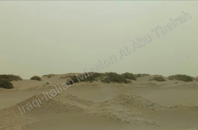
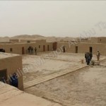
It is one of the hugest and most well preserved archaeological site of Iraq, to be compared with Ur (and possibly also more attractive). Both structures from the oldest period (mid IVth millennium BC) up to the Babylonian time (VIth Century BC) are visible, even if some reconstruction appear too rough-cut. Just like in Ur, a family of guards is in charge of the archaeological area and this has prevented any looting to the site (Abu Qamar, the present guardian, is very famous in Iraq and has been interviewed by many televisions in the last years). One very interesting aspect of the visit is the old house built by the first German archaeologists excavating the Tell at the beginning of the XXth Century AD, where many objects and memoirs can still be seen.
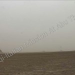
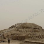
It is, unfortunately, very difficult to reach the site. The road, for the last 20 km, is in the middle of the desert and without a guide it is very easy to get lost. Notwithstanding this, the sight of the Tell, with its huge hill where the ziqqurat was placed, and other minor hills with palace and temple, is unique and really merits a visit
Coordinate Geografiche:
31° 19′ 29.7120″ - 45° 38′ 18.2400″
31.32492° N – 45.6384° E
Governatorato-Distretto-Sub-Distretto:
Al Muthana – Samawa
Città più vicina:
Circa 50 km a nord ovest di Ur, su un antico corso dell’Eufrate. 35 km a nord-est di Samawa.
Quadro Cronologico:
Dalla fine del 5° millennio a.C al 7° secolo d.C. (fine del periodo sassanide).
Scavi:
Il sito di Uruk fu perlustrato da William Loftus nel 1849. Egli ha scavato lì nel 1850 e 1854. Per conto proprio Loftus , ammette che i primi scavi furono superficiali nella migliore delle ipotesi ,e come i suoi finanziatori lo hanno costretto a consegnare grandi reperti museali al minimo costo. Warka è stata anche esplorata dall’archeologo Walter Andrae nel 1902.
Dal 1912-1913, Giulio Giordano e la sua squadra del German Oriental Society scoprì il tempio di Ishtar, uno dei quattro templi noti che si trovano sul sito. I templi di Uruk erano abbastanza notevoli, per come sono stati costruiti con mattoni e decorati con mosaici colorati. Jordan ha anche scoperto una parte del muro della città. Successivamente si è scoperto che questo alto muro di mattoni , 40- 50 piedi (15 m), probabilmente era utilizzato come meccanismo di difesa,e comprendeva totalmente la città per una lunghezza di 9 km (5,6 km). Utilizzando tecniche di datazione di strati sedimentari, questo muro, si stima sia stato eretto intorno al 3000 a.C. Il GOS tornato ad Uruk nel 1928 scavò fino al 1939, quando ebbe luogo la seconda guerra mondiale . Il team è stato guidato da Jordan fino al 1931, poi da A. Nöldeke, Ernst Heinrich, e HJ Lenzen.
Gli scavi tedeschi ripresero dopo la guerra ed erano sotto la direzione di Heinrich Lenzen dal 1953 al 1967. E’ stato seguito nel 1968 da J. Schmidt, e nel 1978 da RM Boehmer. In totale, gli archeologi tedeschi hanno investito 39 stagioni di lavoro ad Uruk.
Recentemente, dal 2001 al 2002, una squadra dell’Istituto Archeologico tedesco guidata da Margarite Van Ess, con Joerg Fassbinder e Helmut Becker, ha condotto un sondaggio parziale con magnetometro ad Uruk. Oltre all’indagine geofisica, sono stati prelevati campioni di carote e fotografie aeree. Ciò è stato seguito da immagini satellitari ad alta risoluzione nel 2005.
Descrizione:
Uruk fu la prima, la più grande, e più longeva città nel periodo più antico della civiltà mesopotamica, sede di complessi templari elaborati ed opere d’arte agli albori della storia, che ha dato il nome al periodo cronologico che va dal 3700-3100 aC circa.
La città archetipico, Uruk, è possessore di tanti superlativi, che, anche se il suo status di prima città è contestata (alcuni studiosi suggeriscono che Karal in Perù potrebbe essere ugualmente antica; siti scavati recentemente nella Mesopotamia settentrionale e in Siria si contendono l’onore di essere considerati prime città, altri sostengono in favore di Chatal Huyuk in Turchia), le dimensioni senza precedenti, l’importanza, e la durata di Uruk la rendono la prima città Mesopotamica.
Certamente, il numero di “primati” ad Uruk è sia lunga sia interessante. Esempi:
- primo tornio noto ad essere usato
- primo noto successo nella crescita del grano nei limiti necessari per l’esplosione di una mini-popolazione
- primo esempio documentato di devastazione ecologica causata da un eccesso di coltivazione e di rapida crescita della popolazione umana;
- prima divisione di tempo in unità di 60;
- primo esempio di scrittura trovati ad Uruk.
Già dalla fine del 4 ° millennio aC., il sito di Uruk copriva 200 ettari, circa 1/3 di quella distesa era ospitata da strutture religiose ed edifici pubblici.L’ attività religiosa è stata focalizzata in due aree, che si sono sviluppate su due precedenti,probabilmente insediamenti separati: la zona dell’Eanna, dedicata ad Inanna, la grande dea dell’amore e della guerra; e del Kullab, il recinto del tempio dedicato a Anu, il dio creatore. Numerosi templi tripartiti (a forma di T) , sale e grandi strutture di funzione sconosciuta erano spesso riccamente decorate con mosaici colorati composti da argilla o coni di pietra attaccati nell’intonaco, o con facciate a nicchie ed incasso. Tra le importanti scoperte a Uruk ci sono: il vaso di Warka, un enorme alabastro (o forse calcare) coperto con rilievi di una processione di offerte a Inanna; e l’ammaliante volto di calcare a grandezza naturale di una donna, la più antica raffigurazione scultorea conosciuta di un volto femminile, forse è la stessa Inanna (entrambi gli oggetti sono stati saccheggiati dal Museo Nazionale dell’Iraq, ma successivamente recuperati).
Durante questo tempo, il sistema di scrittura cuneiforme è stato sviluppato per registrare la distribuzione e lo scambio in una complessa rete che collegava Uruk con insediamenti in Alta Mesopotamia, Iran sud-ovest e sud-est dell’Anatolia, attraverso legami commerciali ed economici, se non forzati. Dal 3100 questo sistema si disintegrò per cause sconosciute, con un grande sconvolgimento ad Uruk. Nel periodo protodinastico, Uruk fu sede di diverse dinastie, i re, tra cui Gilgamesh di fama letteraria che presumibilmente costruì la cinta muraria di circa 10 km di lunghezza, e Lugalzagesi di Umma, che ha unito Sumer solo per cadere in mano a Sargon di Akkad. Dopo la fine di Ur III, la città è declinata solo per rivivere nel 1 ° millennio, quando i suoi templi controllavano vaste proprietà agricole, e fiorì per bene nel periodo Seleucide e Partico, e venne abbandonato definitivamente prima della conquista araba nel 634 dC.
Situazione attuale:
Nonostante si trova al di fuori del confine della provincia del Dhi Qar, la città di Uruk è strettamente legata al quadro culturale e archeologico di questa regione, cosicché in un futuro armonioso lo sviluppo di un potenziale turismo di questa area (culturale) renderà necessaria per ogni turista la visita di Uruk per raggiungere il Dhi Qar.
E ‘uno dei siti archeologici più grandi e meglio conservati dell’Iraq, da confrontare con Ur (e forse anche più interessante). Entrambe le strutture del periodo più antico (metà del IV millennio a.C.) fino all’epoca babilonese (VI secolo aC) sono visibili, anche se qualche ricostruzione sembra troppo grossolana. Proprio come ad Ur, una famiglia di guardie è responsabile della zona archeologica e questo ha impedito qualsiasi saccheggio del sito (Abu Qamar, l’attuale guardiano, è molto famoso in Iraq ed è stato intervistato da molte televisioni negli ultimi anni) . Un aspetto molto interessante della visita è la vecchia casa costruita dai primi archeologi tedeschi che hanno scavato il Tell, all’inizio del XX d.C. , dove molti oggetti e ricordi sono ancora visibili.
È, purtroppo, molto difficile da raggiungere il sito. La strada, per gli ultimi 20 km, è nel bel mezzo del deserto e senza una guida, è molto facile perdersi. Nonostante questo, la vista del Tell, con la sua enorme collina dove è stata collocata la ziqqurat, e altre colline minori con palazzo e il tempio, è unico e davvero merita una visita.
